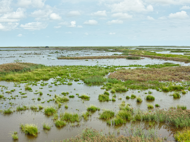
Estuaries are found around the world, offering productive habitat to thousands of species of birds, mammals, fish, and other wildlife.
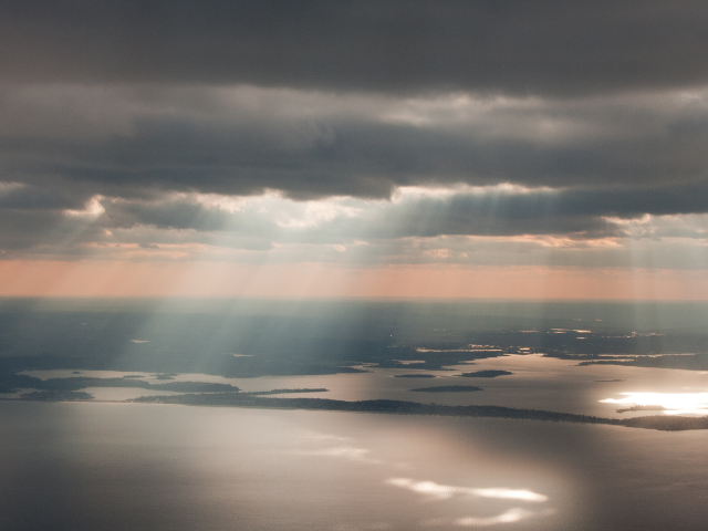
Generally speaking, an estuary is anywhere that a river meets the ocean, typically seen as a place of mixing between fresh and saltwater—though not always! Along the length of an estuary, the water will shift from being mostly fresh near the continent to mostly saline near the sea. Since many estuaries open up into the ocean, the tides will usually have an impact on their waters, altering height and salinity.
More than 100 of these water bodies are found along the coast of the United States. Some famous US estuaries include the New York Harbor, San Francisco Bay, and Puget Sound. The largest estuary in the United States is the Chesapeake Bay, which is 200 miles long and holds more than 18 trillion gallons of water.
A freshwater estuary is created where river water meets lake water. Unlike brackish estuaries that are mixed by the ocean tide, freshwater estuaries are created by storm surges. Freshwater estuaries can be found across the Great Lakes, with more than 20 just on Wisconsin's Lake Superior shore.
Why Are Estuaries Important?
Estuaries are extremely dynamic ecosystems able to sustain a rich variety of habitats and species, making them very attractive places to live for both animals and people. They are home to 22 of the largest 32 cities in the world, and have been prime locations for human communities dating back to at least 3800 BCE.
Estuaries are sometimes referred to as the “nurseries of the sea” because so many animals reproduce there. Most of the fish and shellfish eaten in the United States, from salmon to oysters, live in estuaries during at least part of their life cycle—estuaries provide habitat for about 68% of all commercial fish catch.
While estuaries total only about 13% of the land area in the continental United States, they are home to 40% of the country’s population and account for 47% of its economic output. Coastal economies rely on estuaries for jobs in industries like tourism, shipping, and commercial fishing.
Learn About Estuaries Near You
You can use this interactive map of National Estuarine Research Reserves from the National Oceanic and Atmospheric Administration (NOAA) to find an estuary near you. Learn about a few of the estuaries located in the United States below.
Apalachicola Bay System, Florida
The Apalachicola Bay system is located in the Florida panhandle, where the Apalachicola River meets the Gulf of Mexico. Guarded by a chain of barrier islands, this 210-square-mile estuary receives water from stream systems that reach beyond state borders into Alabama and Georgia. These waters feed the Apalachicola River, contributing to the estuary's standing as one of the most productive estuarine systems in North America.
About 90% of Florida's oyster harvest and 10% of the country's oyster harvest come from these waters, which also serve as a nursery for other commercially and ecologically important species of fish and shellfish. Surrounding the waters of the estuary is a richly diverse landscape, including pine forests, dune fields, barrier islands, floodplain forests, and various types of wetlands. Together, this patchwork landscape provides habitat for over 1,000 species of plants and many different amphibians, reptiles, birds, and mammals, including rare and endangered species, such as West Indian manatee and the Indiana bat. The proximity of the estuary to the Mississippi Flyway, an important track for migratory birds, makes this area an important stopover point for many bird species.
This estuary is managed by the US Fish and Wildlife Service, the US Forest Service, the Florida Fish and Wildlife Conservation Commission, the Florida Division of Forestry, the Florida Department of Environmental Protection, and the Northwest Florida Water Management District, so depending on where you go, there are different opportunities to learn about and interact with the estuary.
- St. Vincent National Wildlife Refuge: This undeveloped barrier island is managed by the US Fish and Wildlife Service, and is an important migratory bird stopover, as well as habitat for bald eagles, loggerhead sea turtles, and red wolves. Visitors here can hike, fish, and photograph wildlife.
- Apalachicola Bay National Estuarine Research Reserve: This 246,000 acre reserve is managed by local, state, and federal agencies, and is a prime forage area for trans-gulf migratory bird species. The refuge offers a guest lecture series, educational exhibits at the nature center, and field trip programs to the site.
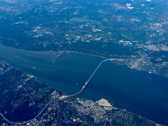
Chesapeake Bay, Maryland and Mid-Atlantic Region
The Chesapeake Bay is 4,480 square miles and its watershed includes six states. It is the largest estuary in the country and the reserve is made up of three sites: Jug Bay (which includes Patuxent River Park and Jug Bay Wetlands Sanctuary), Otter Point Creek, and Monie Bay.
Situated in the mid-Atlantic area of the Atlantic coastal plain, the Chesapeake Bay is a drowned river estuary that was formed as sea level rose after the last ice age and flooded the Susquehanna River valley. Roughly half of the Chesapeake Bay is in Maryland and half is in Virginia. The estuary contains a wide variety of ecosystem types, including estuarine river marshes, estuarine bay marshes, and coastal embayed marshes. These marshes help prevent flooding of upland areas and provide habitat for many species of fish, shellfish, crabs, and waterfowl.
If you want to see more of this majestic estuary without driving through Delaware, Maryland, New York, Pennsylvania, Virginia, West Virginia, and the District of Columbia to do so, check out the virtual tour from the Chesapeake Conservancy.
Elkhorn Slough, California
Estuaries may be a bit tricky to find along the Pacific—only 10-20% of the western coastline of the US is composed of estuaries, compared to 80-90% of the eastern coastline. This stark contrast is due to the difference in tectonic activity on the two coasts; craggy cliffs formed by uplift and mountain-building in the west versus relative calm in the east, where the land slopes gently into the ocean.
Elkhorn Slough (pronounced “slew”) is a small, shallow estuary that feeds into Monterey Bay at Moss Landing, south of San Jose This water body and its surrounding lands offer a wide variety of habitat including mudflats, eelgrass beds, salt marsh, coastal dunes, open beaches, grasslands, and woodlands.
Together, this ecosystem supports more than 50 species of terrestrial mammals and hundreds of species of fish both recreationally and commercially important, but it is best known for its bird population. A critical habitat for resident and migratory bird populations, Elkhorn Slough is one of the few remaining saltwater wetlands on the Pacific Flyway, offering respite to tens of thousands of birds, including rare and endangered species.
The slough and the lands surrounding it are managed by several different organizations, offering different opportunities to learn about and interact with the estuary.
- Elkhorn Slough National Estuarine Research Reserve: Administered by NOAA and owned and managed by the California Department of Fish and Wildlife, this area is a field laboratory for research and education. Come check out the award-winning exhibits of the Visitor Center, or take a stroll along the five miles of trails that span the reserve.
- Elkhorn Slough: Managed by the Elkhorn Slough Foundation, this site covers recreational activities which are offered around the slough, including some not available on the reserve.
Grand Bay, Mississippi and Alabama
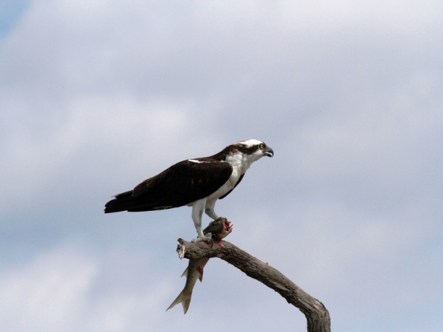
Photo credit: Osprey with Fish - Grand Bay NWR, USFWS, Public Domain
The Grand Bay estuary, straddling the state line between Mississippi and Alabama, is a major estuarine system contributing to the Gulf of Mexico. Encompassing Mississippi's Middle Bay, Point Aux Chenes Bay, Bayou Cumbest, Crooked Bayou, and Bayou Heron, this area contains a diverse array of habitats, including some of the most extensive, un-vegetated salt flats found in Mississippi, as well as wet pine savanna, salt marshes, bays, maritime forests, oyster reefs, and areas of submerged aquatic vegetation.
While the Grand Bay estuary is home to some of the most biodiverse habitats in North America, housing many species of mammals, birds, insects, and commercially and recreationally important species of finfish and shellfish, it isn't an ideal habitat for everyone! This estuary is a study in extremes, both on land and in water.
Low freshwater input to the Bay means that this estuary is one of the saltiest on the Mississippi coast, making it unsuitable for some species while allowing others to flourish. Things don't get much easier on land—to remain healthy, the wet pine savanna is maintained with periodic wildfires, which help to clear out invasive species and are a necessary component of the reproduction of many species of plants in the area. Frequently burned wet pine savannas are often home to specialized plants, such as orchids and carnivorous pitcher plants—at least four different kinds of carnivorous plants can be found in Grand Bay National Wildlife Refuge alone.
Don't let the carnivorous plants keep you at bay! There are many great ways to get out and enjoy recreating on the estuary:
- Grand Bay National Wildlife Refuge: Visitors can enjoy hiking, fishing, hunting, and wildlife observation and take in environmental education and interpretive events at the refuge, managed by the US Fish and Wildlife Service.
- Grand Bay National Estuarine Research Reserve: Managed by NOAA and the Mississippi Department of Marine Resources, the reserve is dedicated to research, but it can also be enjoyed by visitors looking to do some birding, canoeing, kayaking, fishing, hunting, and more.
Great Bay Estuary, New Hampshire and Maine
Photo credit: Great Bay NWR, Matt Poole/USFWS, Public Domain
The Great Bay estuary is unusual, and can even be a little hard to find. This is because New Hampshire's largest estuarine system, located on the border between New Hampshire and Maine, does not open directly into the ocean! Instead, this estuary is fed salt water that travels from the Gulf of Maine 15 miles inland through the Piscataqua River, where it then mixes in Great Bay with fresh water from the Salmon Falls, Cocheco, Bellamy, Oyster, Lamprey, Squamscott, and Winnicut rivers. The bay's placement so far away from the coast makes it one of the most recessed estuaries in the nation.
Formed by sea level rise at the end of the last ice age 14,000 years ago, the estuary and its surrounding lands today contain mudflats, salt marshes, swamps, ponds, eelgrass beds, oyster habitat, and more, offering food, shelter, and breeding ground to fish, birds, mammals, and invertebrates alike. Located on the Atlantic Flyway, Great Bay hosts the largest wintering population of bald eagles in New England, and the largest concentration of black ducks in the state.
Come visit the estuary! Hike, bike, and try your hand at nature photography at the Great Bay National Wildlife Refuge, or head out to the Great Bay National Estuarine Research Reserve for more recreational opportunities. Bring some sunscreen, a water bottle, and a sense of adventure!
The Hudson River, New York and New Jersey
For those who aren't native to New York or New Jersey, hearing that the Hudson River is actually an estuary may come as a surprise! The river begins 315 miles away from the coast as fresh water from Lake Tear of the Clouds in the Adirondack Mountains, and flows south towards Upper New York Bay, also called New York Harbor. Of this extent, only the southern 153 miles (from Troy, New York, to the Harbor) make up the estuary. This designation comes from the unusual trait the Hudson acquires in its final stretch—it will flow two different ways, depending on the time of day.
The waters of the Hudson are affected by the Atlantic's tides, meaning that when the New York coast is experiencing a flood tide (when the tide is rising) the tidal force is so strong that it rushes in through the bay and pushes the Hudson's waters back upstream. The tides are forceful enough that they impact the flow of the Hudson's waters all the way through the Albany area, finally losing their influence at the city of Troy. During an ebb tide (when the tide is receding), the Hudson's waters flow south once again. The Hudson sees two high tides and two low tides each day, constantly shifting the water's flow.
Not only does the Atlantic change the Hudson's direction of flow, but it also affects the water's salinity. Depending on the season, the “salt front,” or the leading edge of the salt water flowing in from the bay, shifts along the Hudson's track. In the high-river flow of spring, the freshwater of the river pushes the salt front south to the Tappan Zee, but as the flow decreases in the summer, the salt front encroaches north to Newburgh Bay, sometimes even reaching Poughkeepsie in times of drought.
This unusual water body and its tributaries are home to more than 200 species of fish, as well as blue crab, bald eagles, herons, and other waterfowl, which can be found in the estuary's tidal marshes and mudflats.
You can help safeguard the estuary! The New York State Department of Environmental Conservation provides a wide range of educational resources and volunteer opportunities.
Jacques Cousteau National Estuarine Research Reserve, New Jersey
The Jacques Cousteau National Estuarine Research Reserve (NERR) in southern New Jersey covers several estuarine areas, including the Mullica River-Great Bay estuary, the lower Barnegat Bay, Little Bay, Reeds Bay, and Absecon Bay. Encompassed in these lands and waters are pine-oak forests, hardwood swamps, tidal marshes, barrier islands, and emergent wetlands, which provide nursery and reproductive habitat to wildlife populations including more than 270 species of macroinvertebrates, 90 species of fish, 350 species of algae, and many more avian, reptilian, amphibian, and mammalian species.
In addition to the plants and animals that live in the estuary all year long, the Jacques Cousteau NERR also serves migrating bird populations, providing winter habitat to more than 70,000 individual waterfowl.
The sponge-like quality of the wetlands surrounding the estuary waters helps to absorb incoming floodwaters and storm surge, and the emergent plants and submerged aquatic vegetation of the estuary filter out sediment, excess nutrients, and pollution from the waters before they flow out to the ocean, making the land habitable for plants and animals while keeping human coastal communities safe and livable.
To visit the area and see the estuary in action, check out these public lands:
Jobos Bay, Puerto Rico
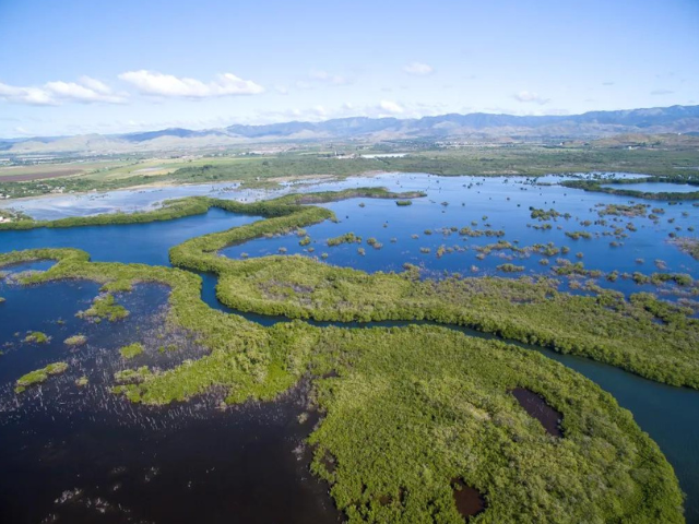
Jobos Bay is Puerto Rico's second-largest estuarine area, and it is home to some of the most extensive networks of mangrove forests on the island. Located on the arid southeastern coast between Guayama and Salinas, this tropical estuarine system was formed 18,000 years ago at the end of the last ice age as rising seas drowned coastal lowlands.
What's unusual about this estuary is its hydrology—rather than being fed by a mighty river, the main source of fresh water for Jobos Bay is groundwater from the South Coastal Alluvial Plain aquifer. Water from the higher-rainfall area of the Cordillera Central mountain slopes is absorbed into the earth and enters the aquifer, where it travels underground across the island before resurfacing in the estuary to the south. With this system, Jobos Bay supports mangroves, coral reefs, lagoons, salt flats, dry forests, and seagrass beds, which are important for a wide array of plants and animals, including large migrating bird populations and many endangered species.
The Jobos Bay estuary has natural water filtration occurring in its mangrove forests. Mangroves are found all around this estuary, including Mar Negro, the mangrove forest wetlands complex found on the land side of the mouth of the Jobos Bay, and Cayos Caribe, the linear chain of 15 reef-fringed mangrove islands that reach west from the southern tip of the mouth of the Bay. These trees help to mitigate the impacts of coastal storms, both for human populations on the land and for aquatic communities on the other side of the forests in the sea.
Kachemak Bay, Alaska
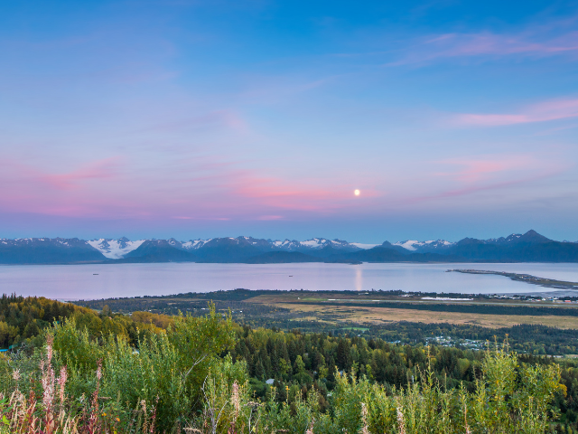
Located on the southern end of the Kenai Peninsula in south-central Alaska, Kachemak Bay is the largest unit in the National Estuarine Research Reserve system, covering 366,100 acres.
Kachemak is a fjord-type estuary, where retreating glaciers carved a deep channel in the land reaching out into the Gulf of Alaska. As the glaciers scraped across the land, they chiseled out a large mass of dirt and rock, which formed a pile that the glaciers pushed across the continental crust. When the glaciers finally reached the end of their path and melted away, they left behind this pile of rubble, otherwise known as a moraine.
As sea levels rose at the end of the last ice age with the influx of water from melting across the planet, this new valley was filled with seawater, drowning the moraine. The moraine rests at what is now the mouth of Kachemak Bay, acting as a barrier to the water body and restricting saltwater input, giving the bay its distinction as a fjord-type estuary.
Fjord-type estuaries typically have a layer of fresh water coming off of the coast flowing above the near-stagnant saltwater below, but Kachemak is located at such a high latitude that during the six-month winter the mainland watershed freezes, cutting off the supply of fresh water to the estuary, rendering the bay almost completely marine.
Thinking of visiting Kachemak Bay for some hiking, fishing, camping, or kayaking? Check out this helpful advice from the Alaskan Department of Natural Resources to keep yourself and the bay safe during your trip!
Mission-Aransas Estuary, Texas
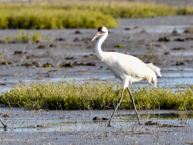
The Mission-Aransas National Estuarine Research Reserve on the Gulf Coast of Texas contains 185,708 acres of wetland, water, and terrestrial habitats, including oak motte habitats, saltwater marshes, wind tidal flats, mangroves, oyster reefs, and coastal prairie. Protected by Matagorda Island, a barrier island created during the melting of the last ice age, this estuary is shielded from some of the winds and waves coming in off of the Gulf of Mexico, making it an ideal home for ecologically, commercially, and recreationally important species such as blue crabs, alligators, juvenile flounder, and herons. Migratory birds also make up a large part of the community here, as the reserve is ideally located as a place to rest and refuel for Neotropical birds migrating between North and Central America.
Perhaps you've heard about the stars of the estuary, although it's unlikely that you've seen them in the wild—the whooping crane, the rarest crane species and one of the rarest birds in North America (and also the tallest). This flock travels 2,500 miles from their home in Canada's Wood Buffalo National Park down to the Mission-Aransas Estuary every year, the progeny of the 15 cranes found wintering at the Aransas National Wildlife Refuge in 1941.
Want a chance to spot these beautiful birds? Visit the estuary between October and March, when the flock is in town for the winter. Aransas National Wildlife Refuge or one of the Mission-Aransas National Estuarine Research Reserve facilities are both great places to go learn more!
Old Woman Creek, Ohio
Photo credit: Ohio DNR
You won't find Old Woman Creek on the West Coast feeding into the Pacific, nor will you find it on the East Coast spilling out into the Atlantic. In fact, this estuary has no access to salt water at all! Old Woman Creek is a freshwater estuary located in Huron, Ohio, where water from the creek mixes with the chemically distinct water of Lake Erie, creating a highly productive wildlife habitat, including freshwater marshes, swamp forests, a barrier beach, upland forests, and a riparian stream, all scattered across the estuary's watershed.
The estuary and its surrounding landscape help to remove pollutants and sediment from water flowing off of the landscape before it hits Lake Erie, which supplies water to millions of Ohio residents every day. In addition to helping provide potable water to the people of Ohio, Old Woman Creek estuary also serves as a giant protective sponge, soaking up potentially dangerous floodwaters and slowly releasing the excess moisture back to the open lake.
Interested in visiting Old Woman Creek? Check out the reserve's calendar of events to plan your visit!
How You Can Protect Estuaries
Estuaries are fragile ecosystems. Winds, waves, and tidal currents can damage them. Human activity can also cause habitat loss or pollution. Impacts from climate change, such as rising sea levels, altered rail patterns, drought, and ocean acidification are growing concerns.
Help protect estuaries by following these tips from NOAA:
- Respect animal habitats when visiting coastal communities.
- Buy biodegradable products and think before you pour chemicals down the drain—they ultimately can end up in estuaries and ocean waters.
- Respect seasons and limits when fishing.
- Keep toxins out of the water by using non-toxic alternatives to pesticides.
- Take action by organizing a beach or stream clean-up.
- Take NEEF’s Watershed Sleuth Challenge to learn more about your watershed—what it is, why it’s important, and what you can do to help protect it, as you earn badges at each level of this three-part course.